As a small country, Nepal has tremendous topographical diversity and presents amazing geographical features in the width of only 230 kilometers from North to South. Landlocked by India on the south, east and west and by China in the north, Nepal contains the highest elevations in the world. The geographical difference in the country ranges from snowy mountain peaks touching the skies with elevations ranging from 5,357 meters of the Gokyo RI and the 8,848 meter of Mount Everest to the dry, arid and corroding desert-like terrain of Mustang with ash-like cliffs and mysterious mountain caves. The Himalayas of the country are the major sources of many rivers and glaciers and play an important role in the country’s economy as well. Settlements and villages on the foothills of the Himalayas and sapphire mountain lakes situated amidst the crevasses of the peaks are only some of Nepal’s wonders. Other famous hallmarks include natural attributes like wide gaping river basins, deep gorges, High Mountain Passes, gorgeous waterfalls, alpine woodlands and forests rich in biodiversity and of course- the high Himalayas themselves. Nepal’s multiculturalism is also one of its many appealing features. The highest mountain peak in the world- Mount Everest is also located in Nepal, along with eight of the fourteen mountain peaks from around the world that surpass the 8000 meter height. The mountain region of the country, occupying 9% of Nepal’s total land, additionally also consists of more than 80 peaks that exceed 7,000 meters. There are many climbable peaks in the region that see lots of mountaineers every year, along with some unclimbed peaks that are held sacred by the local ethnic people. Base camp trekking journeys in Nepal are famous all over the world and the country receives a high influx of visitors to the mountain regions on peak climbing seasons of spring and autumn yearly. Let’s have a look at the top five highest mountains of Nepal-
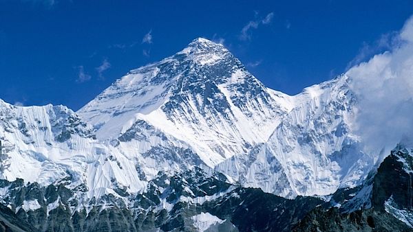
- Sagarmatha (Mount Everest)
Mount Everest is a part of the Mahalangur Himalayan range and it lies in the Khumbu region of Nepal. It is named after Sir Gorge Everest and consists of two main climbing routes, one from Nepal and another from Tibet. It is the world’s highest mountain peak and this characteristic quality has led it to be called “Sagarmatha” in Nepali. The word ‘Sagarmatha’ translates as “the Head of the Sky”. It is also called ‘Chomolungma’ in Tibet. Mount Everest was first climbed in 1953 by a New Zealand mountaineer- Sir Edmund Hillary and Tenzing Norgay Sherpa who was his Nepali Sherpa companion. Mount Everest, as expected, is Nepal’s largest generator of revenue in the tourism and trekking business. The fact that Everest is the most popular mountain peak in the world has made the Everest region the most sought-after trekking region in the country. Due to the commercialization of trekking journeys, the Everest Base Camp Trek has risen in popularity globally; and taking into consideration the many physical attributes of the Everest region like the famous mountain town of Namche Bazaar, the Tengboche Monastery, Sagarmatha National Park and the vantage point of Kalapatthar, the Khumbu region remains at number one in terms of famed trekking destinations from around the planet. The Khumbu is also famous for being a prime Sherpa settlement. The Sherpa people of Nepal are renowned as the best mountain climbers. The Mount Everest massif also consists of the Lhotse peak, the Nuptse Himal and the Changtse. Everest is estimated to be more than 60 million years old and extends into the upper troposphere. The high pinnacle of the mountain also penetrates the stratosphere, exposing it to the jet stream winds that tend to be freezing and move at the speed of about 93.3 kilometers per hour.
Height:8,586 metres.
Also known as "the five treasures of snow"
Location: Taplejung District
Kanchenjunga is the third-highest mountain in the world and is situated about 125 kilometers south-east of Mount Everest. The mountain is shared partly by Sikkim, India. The Kanchenjunga massif consists of five prominent peaks, and these five peaks are also called ‘the five treasures of the snow’ by the local people of the area. The mountains peaks of Kanchenjunga are held as sacred and holy by the people of both Nepal and India and because of its remote location, trekking journeys seldom take place in Nepal- making it an off-the-beaten-paths trekking experience. Kanchenjunga was first climbed on 25th May, 1995 by Joe Brown and Gorge Band; both were part of a British expedition team. The word “Kanchenjunga” comes from Tibet. It roughly translates to “five repositories of great snow”. There is a legend that originates from the local Lhopo people’s beliefs that says that the five treasures of Kanchenjunga are hidden in the mountain slopes and will only reveal themselves to the devout when the world is in grave peril. The five treasures are salt, gold, turquoise, sacred scriptures, invincible armor and medicine. The mountain is a part of the Kanchenjunga Conservation Area and is also believed to be the abode of the omnipotent Goddess Yuma Sammang by the local Limbu people of Nepal. Another myth surrounding the mountain is that of “the Kanchenjunga demon”. Some local people say that the mountain is home to the deity Dzö-nga– a type of yeti or a rakshasa. For generations, there have also been legends recounted by the inhabitants of the areas about a valley of immortality hidden on the slopes of Mountain. The massif of the mountain forms a watershed to several rivers of the area and the main peak of Kanchenjunga is also the source of four main glaciers that flow in the region. When seen from the vantage point of Antu Danda from Ilam, the Kanchenjunga massif looks like a white rugged wall hanging from the sky. There are four climbing routes to reach the summit of the Kanchenjunga Mountain, three lies in Nepal and one in India. Raymond Benson, the author of James Bond books, has also penned down a James Bond adventure in the Kanchenjunga Mountain in his book "High time to kill".
Height:8,516 Metres
Location:Khumbu Region
Also known as " The Mountain Wall of Legend ".
Lhotse is the fourth highest mountain in the world and is a part of the Mount Everest massif. The name of Lhotse comes from Tibet, and its translation means “the South Peak”. It is comprised of three prominent peaks- the main summit which is 8,516 meters, the Lhotse East with elevations of 8,414 meters and the Lhotse Shar at 8,383 meters. Lhotse is a popular alternative to Mount Everest and shares much of the same route as Everest. It lies on the border between Tibet and the Khumbu region and was first climbed by the members of the Swiss mountaineering and Expedition team- Ernst Reiss and Fritz Luchsinger in 1956. They climbed the main summit of Lhotse. On 1970, Sepp Mayerl and Rolf Walter of Austria made the first ascent of Lhotse Shar. Lhotse Middle however, remained unclimbed for a long time, until in 2001- its first ascent was made by Eugeny Vinogradsky, Sergei Timofeev, Alexei Bolotov and Petr Kuznetsov of a Russian expedition. The Lhotse Face is often described as ‘a wall of glacial blue ice’, and the Swiss superstar climber Ueli Steck has also described the bustling atmosphere of the mountain settlements as being, quote- ‘like Hollywood’. A glacier also originates from the Lhotse Shar and adjoins with the Imja Glacier.
Height:8,481
Location: Kumbu Region
Also Known as "The Himalayan Pyramid"
The fifth highest mountain in the world, Mount Makalu is an isolated peak that lies 14 miles (22 kilometers) southeast of Mount Everest on the border between China and Nepal. Rising from the ground, Makalu’s shape resembles a four-sided pyramid of snow and ice. Its name is derived from the Sanskrit word “Maha Kala”. The mountain is named after the Hindu God Shiva, and translates as “the Big Black” in literal English. The mountain also has another name in the local dialect- ‘Kumba Karna’, which means ‘the giant’- named after the legendary giant brother of Ravana from the Hindu epic Ramayana. It consists of two subsidiary peaks as well- the Kangchungtse and the Chomo Lonzo. Chomo Lonzo lies two miles northwest of the main Makalu summit and towers above the Kangshung valley in Tibet. The mountain was first climbed on May 15, 1955 by Lionel Terray and Jean Couzy who were both part of a French expedition. One of the harder eight-thousanders, Makalu is considered one of the most difficult mountains in the world to climb. It is notorious for its steep gradients and knife-edged ridges that are completely open. One of the most highlighted and beguiling feature of visiting Mount Makalu is the beautiful Makalu-Barun Valley. A valley dotted with glaciers and white rivers situated at the base of Makalu in the Sankhuwasabha district of Nepal, the Makalu Barun Valley and Mount Makalu lies entirely inside the Makalu Barun National Park. Brimming with stunning contrasts of high cascading waterfalls that flow into deep gorges, steep rocks and huge boulders rising from lush green forests, and colorful flowers blooming beneath white snow peaks, the valley has a unique landscape that shelters some of the last unsullied mountain ecosystems on the planet. Relatively undisturbed by human kind, rare species of animals and plants flourish in diverse climates and habitats. Due to its isolation, Mount Makalu receives very few trekkers- making it an off-the-beaten-paths destination. The mountain area is mainly occupied by Gurung, Rai and Sherpa people and is culturally rich, presenting many unique biological and traditional treasures. The Barun Valley is also a sanctuary for animals like wolves, lynxes, foxes and beautiful snow-leopards. Makalu made the news in 2006 when the great French climber- Jean Christophe Lafaille, vanished during his ascent of the peak.
Height:8,188 meters
Location:Khumbu Region
Also known as " The turquoise God"
Mount Cho Oyu is the sixth-highest mountain in the world and lies 20 kilometers west of Mount Everest. Cho Oyu is situated between China and Nepal and acts like a natural border between the two countries. The mountain’s name has Tibetan origins and the word ‘Cho Oyu’ means ‘Turquoise Goddess’, a name quite befitting the mountain because of its cerulean tincture. There are many variations of the name of the mountain; it is also often referred to as “the mighty Head of the Goddess”. Another rendition of the name also suggests the mountain’s nomenclature is derived from a Tibetan word that means “the Bald God”. This rendition sprouts from the Tibetan legend of the two Mountain Gods who fell in disarray. According to the legend, the Bald God- Cho Oyu turned his back to Chomolungma- the Mother Goddess Mount Everest, because she refused his proposal of matrimony. Mount Cho Oyu lies at the westernmost section of the Mahalangur Himalayan range and is considered as the easiest climbable peak of 8,000 meters. The mountain also makes up a part of the glaciated High Pass mainly used for trading by the Tibetan and Nepali traders. Long caravans of yaks and mules can be seen all year long on the pass. It was first climbed on October 19th, 1954, by Joseph Jöchler, Herbert Tichy and Sherpa Pasang Dawa Lama of an Austrian expedition. Because of its easy routes to the summit, the mountain became almost as popular as Everest and had the record of most ascends after the world’s highest peak. Although Cho Oyu is rarely climbed from Nepal, routes to its summit do exist. For the majority of time, Cho Oyu is climbed via the western face of Tibet.


Post a Comment